Port Arthur, Coastal Scenery, Convicts, and the Silence That Still Hangs in the Air
Today on our way to Port Arthur we headed out of Hobart over the iconic Tasman Bridge that links Hobart CBD with suburbia. On the night of 5 January 1975, the bulk ore carrier Lake Illawarra struck the bridge, bringing down a huge section of the span into the Derwent River and killing 12 people, including seven crewmen on the ship and motorists who plunged into the dark gap. The city was effectively cut in half, with the eastern shore suddenly isolated, commutes blowing out from minutes to hours, and emergency services scrambling to create ferry services almost overnight. It took more than two years to rebuild the bridge, and the disaster is still remembered as one of the most shocking civilian tragedies in Tasmania’s history. The Lake Illawarra is still down there in the river. Read more about it.
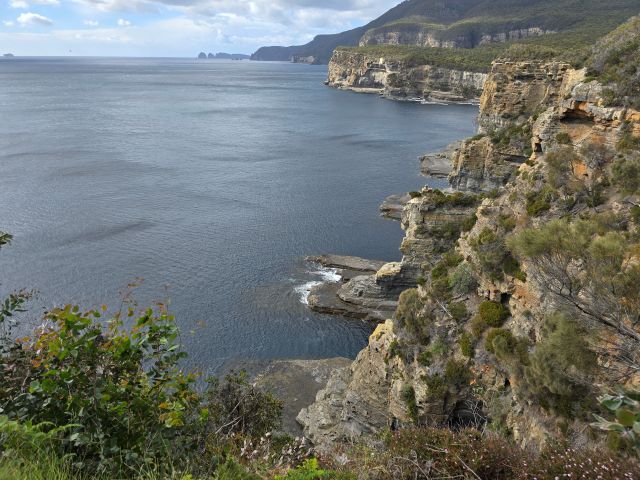
We drove down to the wild and beautiful coastal country to see Tasman Arch and the Devils Kitchen, both looking suitably dramatic under a brooding sky. They were carved out of solid rock by relentless wave action, exploiting cracks and weak points in the cliffs over thousands of years. What began as sea caves eventually collapsed in places, leaving the dramatic arch and the deep chasm that still booms and roars when the ocean surges in.

From there we arrived at one of the most confronting places in Australia.
The Road to Nowhere – Port Arthur

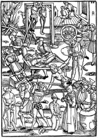
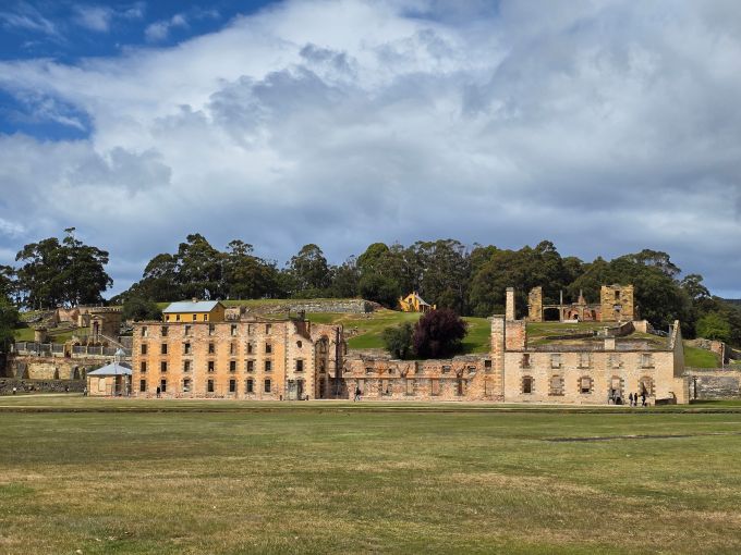
Our guide explained how men ended up here, and it wasn’t because they pinched a loaf of bread. Most were transported as habitual criminals, sent halfway around the world and then dumped into a system designed to break them. Port Arthur was a men-only settlement, and life here was brutally hard. Beatings with the cat ‘o nine tails was routine. This wasn’t just a prison, it was an industrial operation. The convicts produced furniture, stoneware, and building materials, turning misery into profit for the colony.
We explored some of the restored buildings and ruins on a guided walking tour. Even with modern paths and neat signage, it’s impossible not to feel the weight of the place. The wind howled through broken walls, showers blew in and vanished just as quickly, and I kept thinking how relentless this must have felt to people who never got to leave.
The whole pennisula where Port Arthur is located was effectively the prison. Dogs were chained across Eaglehawk Neck to catch escapees and sharks were encouraged in nearby waters. But back then most people couldn’t swim.
We looked at the site’s impressive visitor centre. There’s lot to see and do there, including an impressive model of Port Arthur in its heyday. There are also storyboards that tell a little about individual convicts. A lot of them were very young. Check out the website.

On the Water
After the walk we boarded a boat for a 30-minute cruise on Carnarvon Bay. From the water, Port Arthur looks almost peaceful, green hills, grey stone, reflections broken by rain squalls. It’s a strange contrast, beauty wrapped around such a harsh past. We sailed past the Isle of the Dead which served as the cemetery. We could see the gravestones erected for soldiers and managers. The convicts didn’t get grave markers that would survive.
The Story They Don’t Tell
There’s another layer of history here that isn’t part of the official tour. In 1996, Martin Bryant murdered 35 people at Port Arthur in Australia’s worst mass shooting. The site doesn’t dwell on it, and I understand why, but for overseas readers it matters. That tragedy changed Australian gun laws almost overnight and reshaped the country’s attitude to firearms. You can walk these grounds today without a single mention of it, yet the silence somehow feels louder because of what happened. There is a memorial garden built around the remains of the Broad Arrow café where most of the killings took place. Find out more here.
After a lunch of simple sandwiches, on the way back to Hobart we took a look at the tessellated pavement. Tessellated pavement is a rare rock formation where flat stone breaks up into a pattern of neat rectangles, almost like a tiled floor. It forms when salt crystals and repeated wetting and drying widen natural cracks in the rock over thousands of years. At Eaglehawk Neck the patterns are so regular it looks man-made, but it’s pure geology showing off.

We headed back to Hobart, still dodging showers and leaning into the wind. Port Arthur isn’t an easy place to visit, but it’s an essential one. Some history shouldn’t be comfortable. Dinner that evening was a lovely meal at the hotel. And then off to bed, having made sure the blasted alarm wasn’t going to wake us at 1am.
Tomorrow we’d be meeting Santa.
If you’d like to follow the whole trip, go here.