A visit to Nitmiluk
 Monday 5th August is a holiday here in the Northern Territory. We asked the lady at the supermarket what the occasion was, and after a quick discussion with a couple of other locals, we learned this was picnic day. Probably picnic races, a common event out in the mulga, – actually Darwin Cup day (a horse race). So… picnic day. Do you think we could buy a sandwich for a picnic lunch? Don’t be silly. The shops in town (apart from the supermarket) were closed – but they did have sandwiches in those little triangular plastic packets at a kiosk near Katherine Gorge.
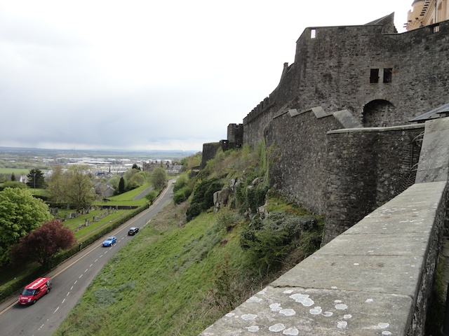
The aboriginal people call the gorge Nimitluk. What an awesome, amazing place. The river has carved its way down through hard limestone, following cracks in the rock. Rockfalls have created dams and now this great river, which is fed only by the annual monsoon, has 13 gorges – separated by those natural dams. They hold water all year round and in this arid land, the place became a magnet for living things.
You can really only appreciate this place from the water, and the air. We took a boat trip that covered the first and second gorges. You walk from one gorge to the next and you don’t need to be a rocket scientist to work out the tour company kept separate boats on each waterway. Although you can hire canoes if you wish, and carry them over the rocks between the gorges.
 The boat drifts between towering cliffs, stained black and yellow by water, algae and minerals. Now, at the end of the Dry, the water is low. In the monsoon the river becomes a raging torrent, filling the gorges and cascading over the rock dams. Waterfalls pour down the cliffs. But at that time, of course, boat trips would be suicidal. We’re told the water rises as much as 18m (nearly 60ft) although a normal Wet Season might be half that. Down at the river’s edge a few trees have managed to grow, bent horizontal to the water by the fury of the flood.
Despite the nine month dry season, parts of the river are seriously deep. One corner is avoided by the aboriginal people. It’s sacred, a resting place of the rainbow serpent. They fear that if they disturb this spot, the serpent will return and destroy the place. The water here is 33m (110ft) deep. In contrast, parts are so shallow the flat-bottomed boat scrapes on the rocks on the bottom.
 This is crocodile country. The locals actively discourage the salt water crocs, which have a nasty habit of eating people. But the smaller, timid Johnson river crocs are welcome. We saw two sunning themselves. The sand bars where these crocs bury their eggs are clearly marked as off limits. Yes, the salties can get up here. The Katherine River flows into the sea and in times of flood, in particular, crocs can end up in any waterway in these parts. If a salty is found in the gorges, it is caught and relocated. The guide said the biggest one they’d ever caught was 3.7m (11ft) – just a baby.
Our guide was one of the few indigenous people I saw working – though I saw lots lounging around town. Seems they earn a very good wage from mining royalties, so they don’t have to do anything. It’s a real shame because our guide was great, displaying a wonderful, dry sense of humour and great knowledge of what he was showing us. I feel there should be more of it, to educate us ignorant whities about their land and what it means to them. The visitor centre is not the same as a local telling you about the things they love.
However, it was a great trip – highly recommended.

I worry about your ‘salties’ but pretty, pretty, pretty! Here’s a site you will love – geoguessr.com
Thanks
I’d love to do a trip up he top end some time. Sounds fantastic. Getting taught by the indigenous locals would be a real eye-opener. Best way to do it. 🙂
Yep, I think the locals should be looking much more seriously at tourism